 |
| "Medieval Street" © 2016-2020 Aleksandr-osm on Deviantart |
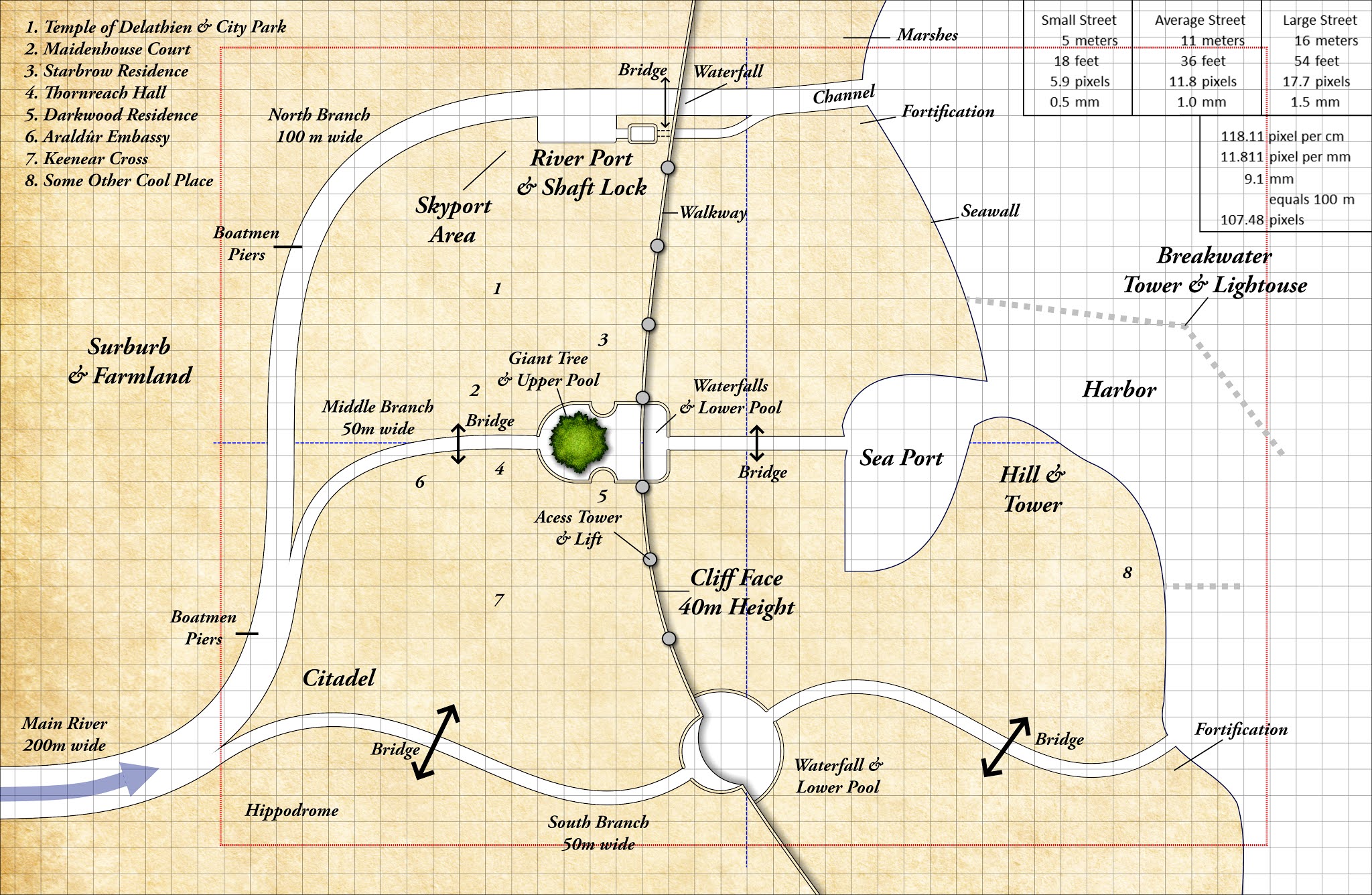
Designing a fantasy city always is a challenge. Other than using random city generators (some of them are fairly good and fun to use), drawing one’s own requires balancing creativity vs. desire for realism, both of which demand planning. The city described here, Mythuín, is a work in progress. I intend to include it in my upcoming gazetteer on Calidar’s elves. I hope to post updates between the early stages shown below and the final result.
The first
step was to establish Mythuín’s physical size and therefore
the scale of the map, and how big the streets would look on paper. After some
back and forth with cartographer Thorfinn Tait, we went for a 1:11,000 scale.
From this, he generated the coastline, based on the existing topographical map
from cal1 In Stranger Skies. The next milestone was to figure out the size
and graphic resolution of the map’s image, with one version intended as a
two-page spread in the gazetteer and the other as an option for a separate 12”x18”
fold up map. The red dotted line on the illustration shown below marks the outside limit of the book’s map. All
in all, the area depicted is about 2 miles north to south (a little over 3 Km). The grid is set to 1 square = 100
meters (330 feet).
From this,
the widths of the streets could be calculated fairly accurately. For example: a
“small” street could be thought as being 18 feet across (a little over 5
meters). On paper, this would be just 2 millimeters thick. I know this actually
works, based on the Glorathon city map from cal1.
Tracing such a street on a computer screen requires a line 6 pixels wide. Actually,
it’s not really as narrow as one might think, so far as Middle Ages streets go.
Those of you living in Europe or Asia know what I mean. I Google-viewed the old
quarter of my home town of Nice, which is a good example of what a medieval
town might look like. Some streets there are 10 feet across (3 meters). It’s
great for shopping and ever so quaint to visit, but they do get pretty crowded.
On the plus side, there’s no car traffic there. At the scale I’m using, these would
show as simple lines, maybe dotted lines on the map.
 |
| Rough Draft 2 City of Mythuín ©2020 Bruce A. Heard. World of Calidar™ Fantasy Setting. |
With all this in place, I can begin “roughing in” streets and boulevards connecting all the key elements described earlier, which will produce city blocks and open areas. The map shown here is just an early draft with labeled details penciled in as guidelines. Click here for Part Two.
 |
| Nice's Old Quarter, Southern France |
No comments:
Post a Comment
Note: Only a member of this blog may post a comment.