Showing posts with label Frisland. Show all posts

Saturday, October 19, 2013

Call of Cthulhu adaptation to Mystara

Outer Beings adaptation to Mystara
In retrospect, I'm very pleased with how the Frisland articles turned out.  Geoff Gander was a key contributor, the original designer for the Outer Beings developed years ago as an adaptation of the Cthulhu mythos for the D&D game.  He will be picking up where I stopped on his blog starting November 1st this year.  As a final note on this--I noticed that once again Blogspot failed to update the bloglist, so this last chapter may go unnoticed by many in the blogosphere.  I am therefore posting another link here for those of you who may have missed the release.  With some luck, the blog list will update this time.  Pretty please. . .

Click Here: The County of Orzafeth

Frisland: The County of Orzafeth

Continued from "Frisland: County of Hosseta"

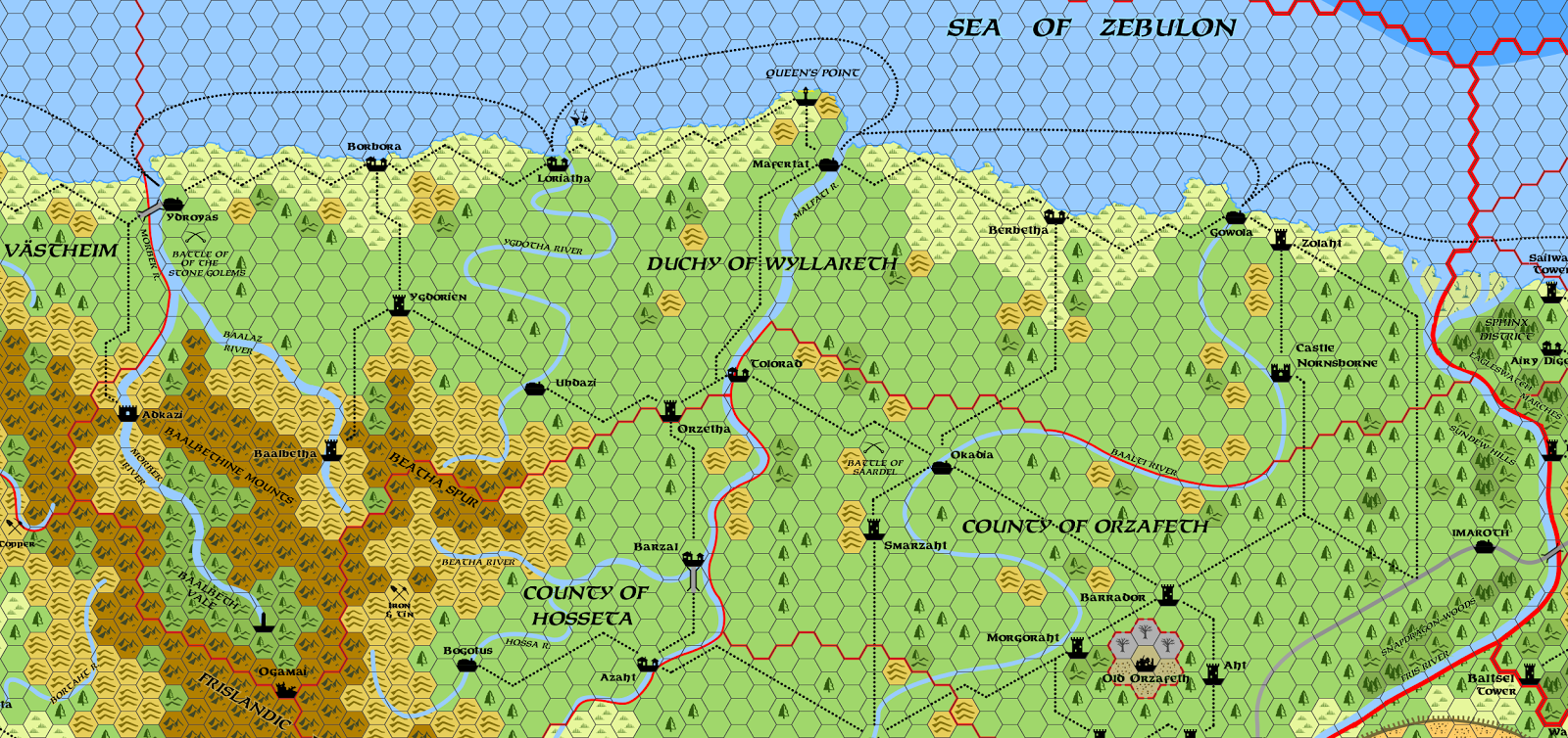
Bone-eaters, jack-o-lanterns, scarecrows, mandragora. . . Orzafeth is a land of many mysteries and dangers. There, risen from ancient times, two sinister willpowers fight to revive their realms. Though supremely deadly, neither are what they seem to be.

Mystara Alphatia Frisland Hex Map
County of Orzafeth -- Map Scale: 8 Miles Per Hex
History: The County of Orzafeth once was a kingdom allied with the Ogam. The original monarchy had accepted mountain tribes and their shamans in its realm in a bid to improve land fertility. It succeeded, but it also led the population to become followers of the Outer Beings. Emanations of chaos engulfed the old kingdom and spilled over into the neighboring realms, prompting them to go on a crusade. Horrors summoned by the shamans defeated the crusaders, which compelled Emperor Alphas III to intervene. The Outer Being worshipers were defeated at great cost. Besieged in their capital city, the last Orzafethians self-destructed during a lurid ritual, their souls departing to feed their outer world patrons. Since then, the capital city’s twisted ruins have remained cursed and prone to permanent emanations of chaos. The old monarchy having vanished during the self-immolation, Sundsvall appointed a family to administrate the new county, now a dominion of the Kingdom of Greater Frisland. Save for the mountains themselves, Orzafeth is the next most dangerous place in the realm, with unexplained phenomena, poisonous flora cropping up unexpectedly, and bestial incursions spawning from unseen gates. Despite a high military presence and repressive laws, Orzafeth remains a treacherous place to live.

Sunday, September 22, 2013

Frisland: The County of Hosseta

Continued from "Frisland: Maegryn of Searock"

Bulwark of Freedom, Inheritors of the Glorious Banner, Shining Heart of Frisland and Greatest County of them all. . . Not everyone agrees, but Hossetan inflated pride is easily pardoned thanks to their popular beers and fine chocolates.

Mystara Alphatian Frisland Hex Map
County of Hosseta -- Map Scale: 1 hex = 8 miles
Hosseta is the smallest of Frislandic dominions. Its origins go back to a small Alphatian kingdom carved out of the wilderness, before the time of Old Argonath. Tucked between the Malfati River and the northern Kerothar Range, it survived the unkindness of time and war. After the ill-fated Orzafeth crusade had foundered, its old dynasty was replaced as the result of its duplicity in the plot to misinform imperial circles. When the Kingdom of Greater Frisland was reestablished, the small realm returned in the form of a county subject to royal authority in Shiell, with imperial supervision from Sundsvall.

Saturday, September 7, 2013

Frisland: Maegryn of Searock

When Geoff Gander and I chatted about the previous article, he mentioned he was curious about the story behind the Duchess of Wyllareth’s ancestor—the one who brought the curse upon their House. The previous chapter having exceeded 7,500 words, I decided to punt the idea for a later day. Catching the ball in mid flight, Geoff wrote this precious nugget:

Maegryn is a reclusive spellcaster who made her home on the island known in Wyllareth as Searock, near Mafertat, more than a century ago. Calling the damp, salt-encrusted, gull-infested rock an island is at best charitable, as her equally damp and salt-encrusted tower occupies almost every square inch of it. Wyllarethians who are aware of Maegryn believed her to be long dead, but whenever storms lash the shores around Mafertat, the superstitious are prone to recall the legendary rage and spitefulness of the sea-witch.

Mystara Alphatia Frisland Hex Map
Searock Island -- 2 Miles per Hex
History: In truth, Maegryn, in whose veins runs the blood of generations of Antalian sea-witches and Alphatian mages, is the last in her line. She is potent combination which, combined with her passionate nature, produced a powerful, temperamental spellcaster whose mood could affect the very weather around her. Her family was initially well connected to the ducal house of Wyllareth, and Maegryn spent part of her youth as a courtier in Mafertat, where she became known for her forceful, but joyful, personality. Her high spirits caught the eye of the duke's eldest son, Dorelion, and the two enjoyed a romantic liaison.

The time soon came for Dorelion to spend a season at the imperial court in Sundsvall to complete his education, and he left her his ring as a promise. He soon forgot Maegryn amid the parties and trysts with girls who had more distinguished bloodlines. In the meantime Maegryn waited in Mafertat and obsessed over her promise ring while planning her marriage. Her closest friends, who had connections in Sundsvall and had learned what Dorelion was doing, advised her to forget the future duke and find her own happiness. She would have none of it. Dorelion returned months later, with a young bride. Devastated, Maegryn withdrew for weeks while Mafertat suffered the worst weather ever recorded.

Wednesday, August 14, 2013

Frisland: The Duchy of Wyllareth

Continued from "The County of Västheim"

Once ravaged during the fateful Crusade on Ancient Orzafeth, an easy mark thereafter for those dastardly Qeodim raiders, Wyllareth struggled to rebuild itself. After its rebirth as a duchy, its ruler played a new card to solve her predicament. . . or did she?

Mystara Alphatia Frisland Hex Map
Duchy of Wyllareth -- Map Scale: 8  Miles per Hex
This oblong province runs nearly 400 miles east to west, and 168 miles north to south at its widest spot. Save for the Baalbeth Vale, Wyllareth is as hilly as a flounder stuck under Thor’s hammer. . . and about as joyful. It is a sinister land, overcast, cold, windy, devoid of much population, and marked with scars of war still visible to this day. Wrecked towns and strongholds altogether fail to qualify as ruins, but more as ruins of ruins, following the vicious de-Orzafething campaign to eradicate all things harking of Outer Beings. What Alphatian inquisitors did not raze had already been desecrated, crushed, and desecrated once more by the fiends of Orzafeth. What little was left was hastily buried or scattered.

Thursday, August 1, 2013

Frisland: The County of Västheim

Continued from "The Marquisate of Azafeth"

At the tip of the northwestern corner of Alphatia lies the land of a conquered people yearning to regain their freedom. But what can an isolated culture truly hope to gain in the face of the mighty Alphatian Empire?

Mystara Alphatia Frisland Hex Map
County of Västheim -- Map Scale: 8 Miles per Hex
Just short of 200 miles north to south and about as wide, Västheim occupies the peninsula along the Strait of Qeodhar. Cold, wet, and wind-beaten, its soggy grasslands and hills surround the northwestern edge of the Kerothar Mountains. Climate along Alphatia’s northern west coast is similar to the one prevailing in real world Anchorage, Alaska—temperatures average between 50° and 65° F. in the summer (from 10° to 18° C.), and 11° to 23° F. in the winter (from –11° to –5° C.) Though winters tend to be mostly cloudy and snowy, weather remains unpredictable; while one year may see several feet of snow accumulation on the ground, another could experience frequent thaws and ice buildup during the nights. Winds generally blow across the Sea of Alphatia. A mild sea current flows from the south before turning eastward around the northernmost cape, and becomes colder in the Strait of Qeodhar. Temperatures drop rapidly in the mountains. In the vicinity of Widzif, daylight hours in the summer exceed those in the winter due to the region’s latitude.

Original settlers were Antalians, fearless navigators and warriors who’d sailed eastward from faraway Brun. They’d named this land Østheim centuries ago, although it later became known as Västheim (pronounced VEST-high’m), the Kingdom of the West, reflecting an Alphatian point of view. It is only one of many changes imposed by the wizardly conquerors. The present county dates back to the establishment of Greater Frisland as a subject kingdom of the Alphatian Empire, centuries after the fall of the old Antalian kingdoms. Since then, the inhabitants have become somewhat more mixed in their cultural and racial heritage. Dark-haired and pale skinned Alphatians as well as copper skinned Cypric have mixed with local Antalians, showing Yanifey influences as well. In Västheim, the Ogam seem like a distant peril, an ugly and shameful disease that struck their southern cousins which, thankfully, has been averted here. In the minds of the locals, it instilled a concept that their land is therefore unsoiled, somehow holier, and more righteous than their neighbors’. Västheim’s relative economic strength, at least from a Frislandic point of view, only helps reinforce this strong parochial mentality.

Sunday, July 21, 2013

Frisland: The Marquisate of Azafeth

Continued from "The Grand Duchy of Frisia"

This strip of land squeezed between the Sea of Alphatia and the Kerothar Mountains is home to descendants of ancient Antalians, their Alphatian overseers, and the sinister Ogam. Behind the orderly façade of imperial law rages a secret fight for survival.

Mystara Alphatia Frisland Azafeth Hex Map
Marquisate of Azafeth -- Scale: 1 Hex = 8 Miles

This Frislandic dominion is one of the hardest to administrate because of its narrow, nearly-370-miles-long shape and forbidding terrain intersecting its mid-point. In fact, locals perceive three distinct regions. Northern Azafeth centers around the boomtown of Nasta. The southern region, anchored around Zuuldal, includes the Hills of Ygdumma. The midsection lies within the Västmark Shield, a rocky spur of jagged ridges and narrow valleys. Coastal residents don’t think of the hills and mountains in the east as part of the marquisate, for the Ogam dwell there. Townsfolk see the short, swarthy goat herders as little more than beastmen who would enslave and sacrifice them all to their evil gods if given the chance—a belief that isn’t remotely preposterous. Climate along the coast is similar to the one prevailing in real world Glasgow, U.K.—cool and rainy. Winds generally blow from the west, and a mild sea current flows from the south. Temperatures drop rapidly in the mountains.

Sunday, June 30, 2013

Frisland: The Grand Duchy of Frisia

Continued from "The Alphatian Province of Frisland"

Political center of Greater Frisland and an island of population largely cut off from the rest of the kingdom, the grand duchy embodies Frislandic paradigms. Edjer the Twisted, King and Grand Duke by Imperial Right, rules the troublesome realm in a game that carefully balances the mission imposed upon him by Sundsvall, and his own perfidious schemes to enrich himself while maintaining control over his vassals.

Mystara Alphatia Frisland Hex Map
Grand Duchy of Frisia -- Map Scale: 1 Hex equals 8 Miles
This grand duchy includes the plains stretching westward from Lake Shiell. More than 300 miles of foothills at the edge of the Kerothar Mountains mark the opposite border. The province skirts the dark realm of Blackheart, with mutual borders more than 500 miles long lying mostly along the turbid, monster-infested Rainbow River. Two other major rivers cross the dominion: the Baalti, flowing northward into Orzafeth, and the Shiell River. Roads and waterways, as dangerous as they are, channel population growth. Frisian immigration sees Neo-Orzafethians and Wyllarethians moving from the north along the Baalti, especially in the Witival area. These include people of Yanifey, Bellissarian, and Esterhold ancestry. Ethnic Alphatians generally sail in across Lake Shiell from Foresthome. Between these two groups of people lie the Creeping Woods, a large forest at the center of the open plains which marks the limit of settled areas spreading from Lake Shiell’s western bank. Farther west stand the strongholds of Zulaht, in the vast Zolantha Grasslands, and Alinoor on the Rainbow River. These two outposts are tasked with the challenging mission to patrol the foothills and watch for Ogam encroachment, especially the Barbazi Hills. At the extreme south lie the Hills of Orzaal, which are claimed "on paper" by the kingdom but remain largely uncontrolled.

Sunday, June 9, 2013

The Alphatian Province of Frisland

Continued from "Ambur: the County of Stargaze"

This kingdom at the northwestern tip of the Wizards’ Empire stands amongst the largest in mainland Alphatia and bears a most tumultuous history. Despite its harsh climate and inhospitable land, Frisland became a battleground for races, cultures, and faiths. A legacy of horror and of ancient evils still imbues the region, which to this day survives Alphatia’s efforts to scour the province of its troublesome heritage.

Mystara Alphatia Frisland Hex Map
Kingdom of Greater Frisland (AC 1000) -- Map Scale: 8 Miles per Hex
Frisland’s Origins: In its very distant past, Frisland became a refuge for three races, all of them fleeing greater scourges. The Yanifey came first, a copper-skinned race of ancient Neathar stock more prevalent in the island-continent’s east and south. Reeling from the advance of Alphatian forces after their recent landfall on Mystara, the original Yan folk mixed with fey people before retreating into the cold northwestern reaches, on the oriental side of the Kerothar Mountains. The Ogam, slaves of an evil race now extinct, escaped from the Isle of Dawn and reached the shores of Frisland, before finding solace in hidden valleys, deep amid the Kerothar Mountains. At about the same time, Antalians from Brun fled before King Loark’s onslaught, abandoning their ancestral lands to the goblin hordes. These Antalians, a people of fair complexion, sailed from the west, settling the island of Qeodhar first and Frisland’s western shores thereafter.